


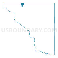
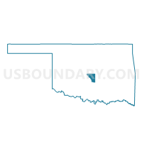
Voting District 37, Cleveland County, Oklahoma
About
Outline

Summary
| Unique Area Identifier | 653769 |
| Name | Voting District 37 |
| County | Cleveland County |
| State | Oklahoma |
| Area (square miles) | 2.38 |
| Land Area (square miles) | 2.34 |
| Water Area (square miles) | 0.04 |
| % of Land Area | 98.34 |
| % of Water Area | 1.66 |
| Latitude of the Internal Point | 35.36687050 |
| Longtitude of the Internal Point | -97.47947920 |
Maps

Graphs
Select a template below for downloading or customizing gragh for Voting District 37, Cleveland County, Oklahoma


Neighbors
Neighoring Voting District (by Name) Neighboring Voting District on the Map
- Voting District 10, Cleveland County, OK
- Voting District 16, Cleveland County, OK
- Voting District 17, Cleveland County, OK
- Voting District 21, Cleveland County, OK
- Voting District 22, Cleveland County, OK
- Voting District 528, Oklahoma County, OK
- Voting District 532, Oklahoma County, OK
- Voting District 533, Oklahoma County, OK
- Voting District 54, Cleveland County, OK
- Voting District 58, Cleveland County, OK
- Voting District 588, Oklahoma County, OK
- Voting District 80, Cleveland County, OK
Top 10 Neighboring County Subdivision (by Population) Neighboring County Subdivision on the Map
- Oklahoma City Southwest CCD, Oklahoma County, OK (429,392)
- Oklahoma City Southeast CCD, Oklahoma County, OK (145,193)
- North Cleveland CCD, Cleveland County, OK (121,027)
Top 10 Neighboring Place (by Population) Neighboring Place on the Map
Top 10 Neighboring Unified School District (by Population) Neighboring Unified School District on the Map
Top 10 Neighboring State Legislative District Lower Chamber (by Population) Neighboring State Legislative District Lower Chamber on the Map
- State House District 53, OK (48,374)
- State House District 54, OK (39,563)
- State House District 92, OK (34,969)
Top 10 Neighboring State Legislative District Upper Chamber (by Population) Neighboring State Legislative District Upper Chamber on the Map
Top 10 Neighboring 111th Congressional District (by Population) Neighboring 111th Congressional District on the Map
Top 10 Neighboring Census Tract (by Population) Neighboring Census Tract on the Map
- Census Tract 1074.01, Oklahoma County, OK (6,402)
- Census Tract 2021.06, Cleveland County, OK (6,183)
- Census Tract 2020.05, Cleveland County, OK (6,173)
- Census Tract 2020.02, Cleveland County, OK (4,244)
- Census Tract 2020.08, Cleveland County, OK (3,825)
- Census Tract 2020.07, Cleveland County, OK (3,607)
- Census Tract 2020.04, Cleveland County, OK (3,588)
- Census Tract 2021.02, Cleveland County, OK (2,454)
- Census Tract 1073.03, Oklahoma County, OK (1,715)